
The lahars downstream
The most devastating product of a volcanic eruption is a lahar, from an Indonesian word for mudflow. Technically, these are actually debris flows and contain relatively little mud, but they are still often referred to as mudflows.
Why do they occur? A volcano is actually a rather porous and fractured body of rock and debris with a relatively high water content. In addition, during an eruption much of the snow and ice on the volcano peak may melt, combining with the contained water to produce a sediment-laden slurry that moves rapidly downhill, sweeping away everything in its path or, at the distal end, burying everything in an abrasive mixture of silt, sand, and gravel.
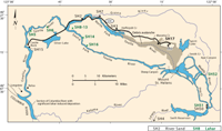
The May 18, 1980 eruption of Mount St Helens produced lahars of several types in most of the drainages surrounding the mountain. In the South Fork of the Toutle River, the first lahar arrived at Gardner Park at about 1015, an hour and a half after the eruption. The biggest lahar, emanating from the debris avalanche, travelled down the North Fork and arrived at the foot of the mountain at about 2300 hours, 12 hours after the eruption. It flowed into the Cowlitz River shortly thereafter and largely filled the channel at Kelso and Longview. From there it moved into the Columbia River where it finally came to rest. It deposited 45 million cubic meters of sand and gravel, reducing the channel depth from 12 m to 3.5 m. The channel was blocked to ocean-going vessels for 13 days.